the Creative Commons Attribution 4.0 License.
the Creative Commons Attribution 4.0 License.
 | 17 Apr 2019
Heliogeophysical prediction service in Poland:past, present and future
Zbigniew Klos
Iwona Stanislawska
Beata Dziak-Jankowska
The Regional Warning Centre (RWC) of Warsaw operates as the Heliogeophysical Forecasting Centre in the Space Research Centre (SRC) of the Polish Academy of Sciences. It is involved in the current collection of a large volume of data exchanged with the International Space Environment Service (ISES) and received directly from various international observatories and Polish-operated geophysical stations. From this continuous flow of data, daily forecasts are issued of space weather conditions and their influence on the performance of technological systems on the Earth and in the space environment. Special services are prepared for governmental and commercial customers, including the SRC. Software packages have been developed for the processing of data and to implement the prediction and forecast systems.


The Institute of Geophysics at the Polish Academy of Sciences was asked in 1973 by the Polish Ministry of Foreign Affairs to improve prediction of high-frequency (HF) propagation conditions for different geographical directions. It was clear to the ionosphere laboratory of the institute that a positive answer to the question depended on reliability of forecasting of solar-terrestrial events on short-term basis and regular daily reporting to the customer. Thus, the current set of operational data, as well as the service type of activity, has been developed. As the data set gathered in Poland was too poor (only Belsk observatory magnetograms and Warsaw–Miedzeszyn ionosonde data were run at the time), the team responsible for this activity, i.e. institute staff members (among others, Andrzej Wernik, Zbigniew Klos, Iwona Stanislawska and Barbara Popielawska), organized reception of ursigram data codes circulated in the frame of IUWDS (International Ursigram World Days Service).
First of all, Zbigniew Klos contacted Paul Simon, the IUWDS secretary, requesting the new code book as well as any information from the IUWDS Steering Committee related to exchange of forecasting data. At the same time, to understand how the data are used and managed in the IUWDS system, Ronald Eyfrig of the Fernmeldetechnisches Zentralamt Forschungsgruppe Ionosphere in Darmstadt was contacted, along with other IUWDS centres, including the World Warning Agency in Boulder as well as the respective centre in Moscow, requesting any instructive materials to help develop the National Warning Contact in Poland. After very positive responses from many sources, the National Warning Contact was established very soon and started to receive daily data from Boulder (by means of the international Morse code), Darmstadt (telex), Meudon (telex), Prague and Moscow (telex and radio).
Finally, at the end of 1974, the national IUWDS contact started to operate routinely, and service to customers slowly developed. The incoming information was processed, and on this basis, short reviews of heliogeophysical activity and forecast were made daily. As a result, P. Simon, in his letter from 15 April 1975, invited the National Warning Contact in Warsaw to participate, with its activity in real solar–geophysical forecasting as an Associate Warning Centre of IUWDS. However, the Institute of Geophysics was waiting for the decision of the authority of the National URSI Committee to participate in this kind of activity, and a positive decision was obtained in August 1975. In 1977 the Ionosphere Laboratory was transferred from the Institute of Geophysics Polish Academy of Sciences to the newly created Space Research Centre at the Polish Academy of Sciences.
The Heliogeophysical Prediction Service Laboratory was organized in this centre, taking over the responsibility for the domain in question. At the same time the IUWDS Steering Committee approved the status of the Associated Regional Warning Centre Warsaw (ARWC) at its next meeting at Grenoble in 1978.
After granting the Space Research Centre at the Polish Academy of Sciences (PAS) in Warsaw the ARWC status, it soon became clear that computer aid for heliogeophysical data management needed to be implemented in all layers of activity.
The ARWC Warsaw has developed its activity in four areas, namely the following:
-
A set of codes was developed to work on numerical processing of data and assist in elaborating methods of numerical forecasting of the event characteristics.
-
The data from globally distributed sounding stations (initially in IUWDS, now in the International Space Environment Service – ISES) were processed to model the profiles of electron concentration.
-
A practical prediction computer program for HF propagation conditions was developed.
-
Promotion of our services was implemented to build market-oriented sectors of users.
However, there were no desktop computers in the 1970s. Thus, it was only possible to implement these tasks as a system called KAZIA, using the existing minicomputer with restricted memory and operational system (Stasiewicz et al., 1979). The ARWC Warsaw has paved the way in that direction.
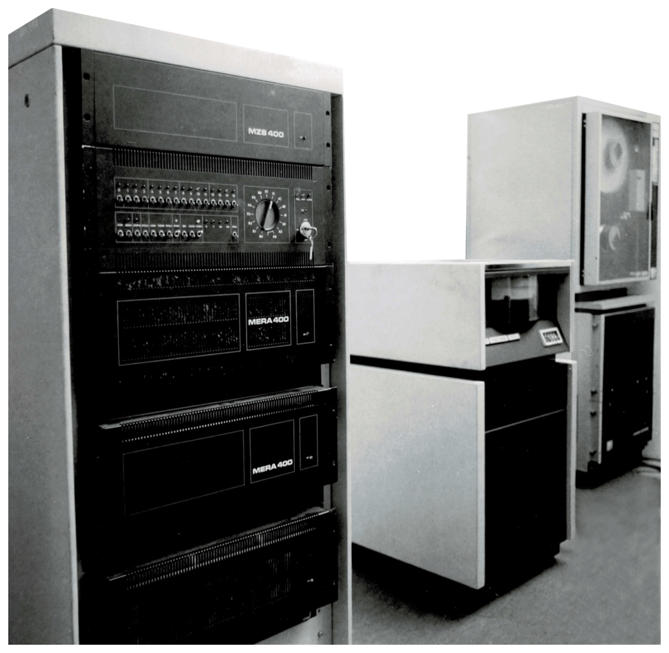
Figure 1The minicomputer MERA-400 used to run the HELGEO system for ursigram and instantaneous data processing.
A computer-based system for data gathering and display, numerical prediction, and forecast evaluation was implemented in 1980 (Klos and Stanislawska, 1986). The minimum equipment necessary to operate the systems, called KAZIA and HELGEO, consisted of a minicomputer with 32 kB memory, a magnetic tape or disk for storage, and a telephone modem. The minicomputer MERA-400 produced in Poland is fully devoted to managing HELGEO is shown in Fig. 1. Teletype was the only option for accessing IUWDS data.
The flow-chart algorithm of data reception, forecast and verification was as follows:
-
The coded data (ursigrams) received by teletype and messages by means of the international Morse code were entered on punched or magnetic type. The same was done with local data.
-
The coded data were read into the computer, decoded, checked and corrected.
-
The corrected data were decoded and tabulated by the computer in specified selected topics, displayed and printed.
Next, many subroutines of the program ordered the decoded data and prepared the report on solar and geophysical activity. The reports after manual correction, if needed, were transmitted to the user.
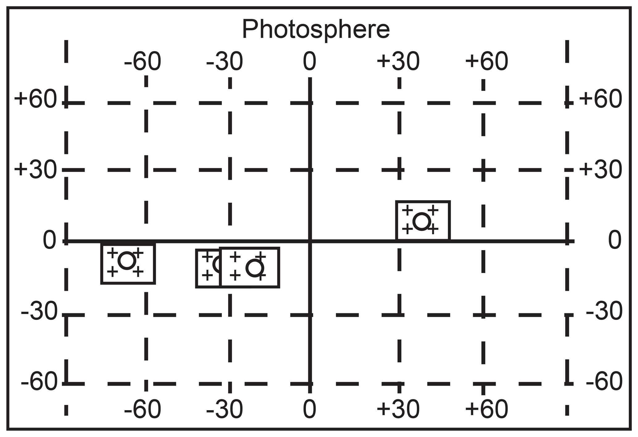
Figure 2The example of HELIOMAP, a current graphical display of events observed at the solar disc provided by the subroutine of HELGEO.
The modular construction of the system made it possible to improve, replace or add specific modules. The decoded, averaged and key data were displayed in tabular form. The subroutine HELIOMAP presented a graphical display of active centre features and other events like flares at the solar surface.
The users were able to receive daily the product by teletype or by telephone on their own minicomputer terminals. However, the real terminal mode of communication was used online (very slow speed of data transfer) only by the radio-communication unit of the Ministry of Defense. Other users like radio-communication units of the Ministry of Foreign Affairs, the Polish Airline LOT and the Ministry of Interior Affairs preferred teletype messages. It was daily information.
The HELGEO product had two parts: reports on the current situation and the forecasts. The reports were related to optical, X-ray, and radio flares and to other parameters of solar activity (like the area of active regions), geomagnetic and ionospheric conditions and disturbances, and radio-wave propagation conditions for various geographical directions and times.
The second part presented prediction of X-ray flares, probability of optical flares and the probability of SWF (short-wave fadeout) occurrence, severity and duration. An algorithm for predicting the number of solar flares from a particular active region was based on an analysis done by Jakimiec and Wasiucionek (1979). The prediction itself was made on the basis of several widely used parameters of active regions observed 1 day earlier. It was possible to get the probable number and class of the flares which might occur during the considered day. The algorithm was based on second-order regression equation derived from a statistical analysis of solar data. The transition to the X-ray classification (C, M and X) was done on the base of Jakimiec and Wasiucionek (1979) formula. The system also included prediction of geomagnetic and ionospheric storms as well as indices of radio-wave propagation conditions over several paths.
The subroutine of the program designed for forecast evaluation processed the prediction and was compared to the outcome. The statistics of these differences were gathered and displayed.
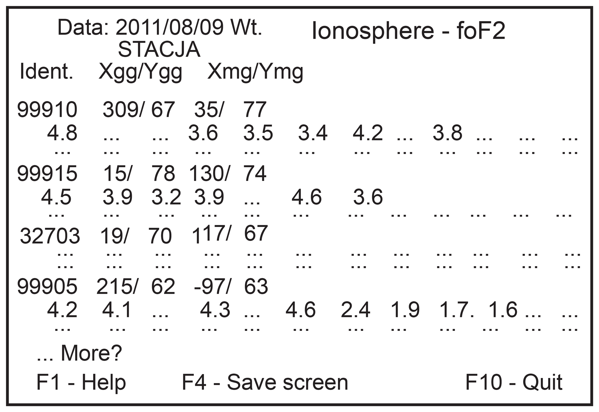
Figure 3The example of ionospheric foF2 display observed at every single station provided by HELGEO.
The status as a full Regional Warning Centre (RWC) was granted to ARWC Warsaw in 1992. Along with the coming of the personal computer (PC) revolution, IUWDS evolved into ISES, merging the information society with the needs of modern technology to answer the challenges of space weather. This situation modified the RWC Warsaw activity as well. The operation of the HELGEO system was reconfigured. PC machines with an implemented HELGEO system were located at the users' desks at their locations, and only the key heliogeophysical parameters were sent to them. This optimized the flexibility of telecommunication transfer. However, again, only the military users explored this new solution effectively.
At that time the RWC Warsaw started to perform its duty as the following:
-
a data provider,
-
a service provider,
-
an applied science developer related to space weather data assessment, modelling and prediction techniques.

Figure 4The first HELGEO system configuration (designed in 1977 and implemented in 1979) presented at the first Solar Terrestrial Prediction Workshop in Boulder in 1979.
3.1 Data provider
The RWC Warsaw was involved in current collection of large portion of data received directly from the following:
-
various international observatories within the frame of ISES and directly from observatories all over the world.
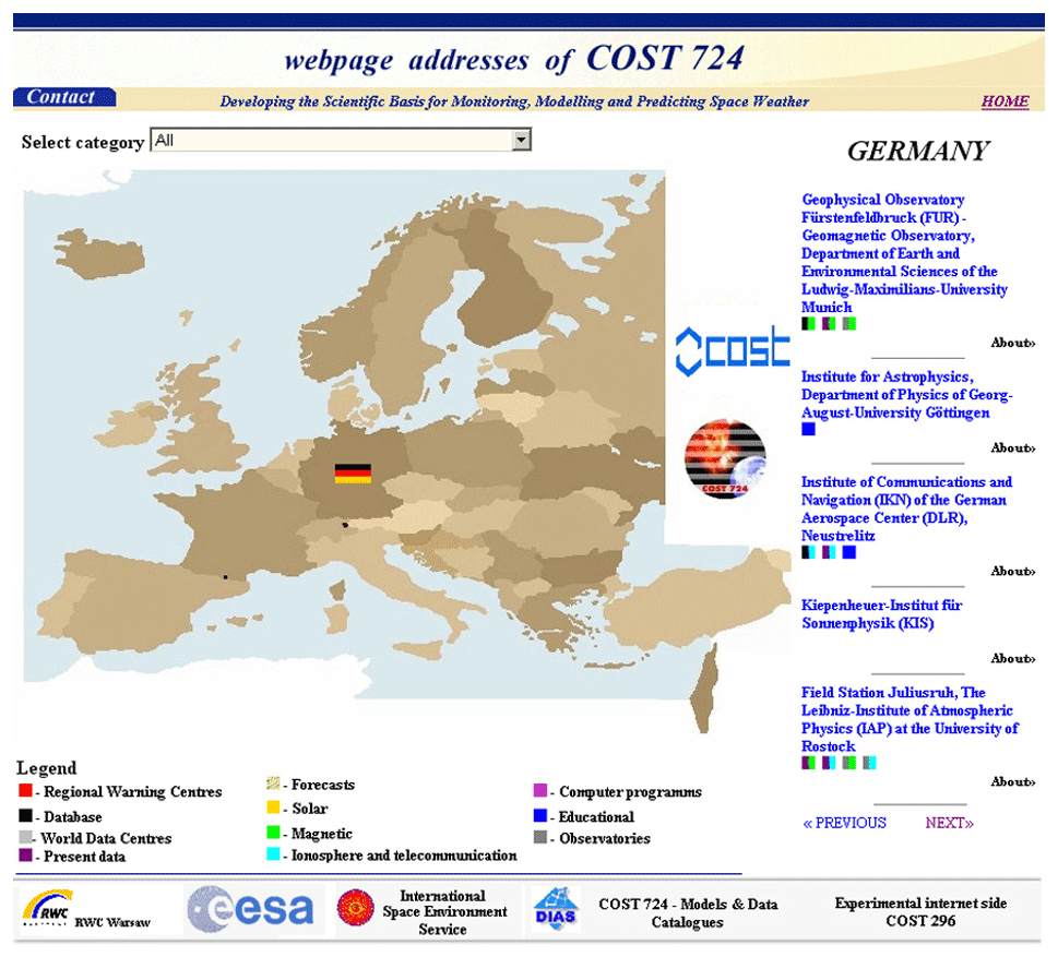
Figure 5Navigator for European web pages related to space weather: http://www.cbk.waw.pl/sweurope/ (page closed: 1 January 2009, last access: 31 December 2008).
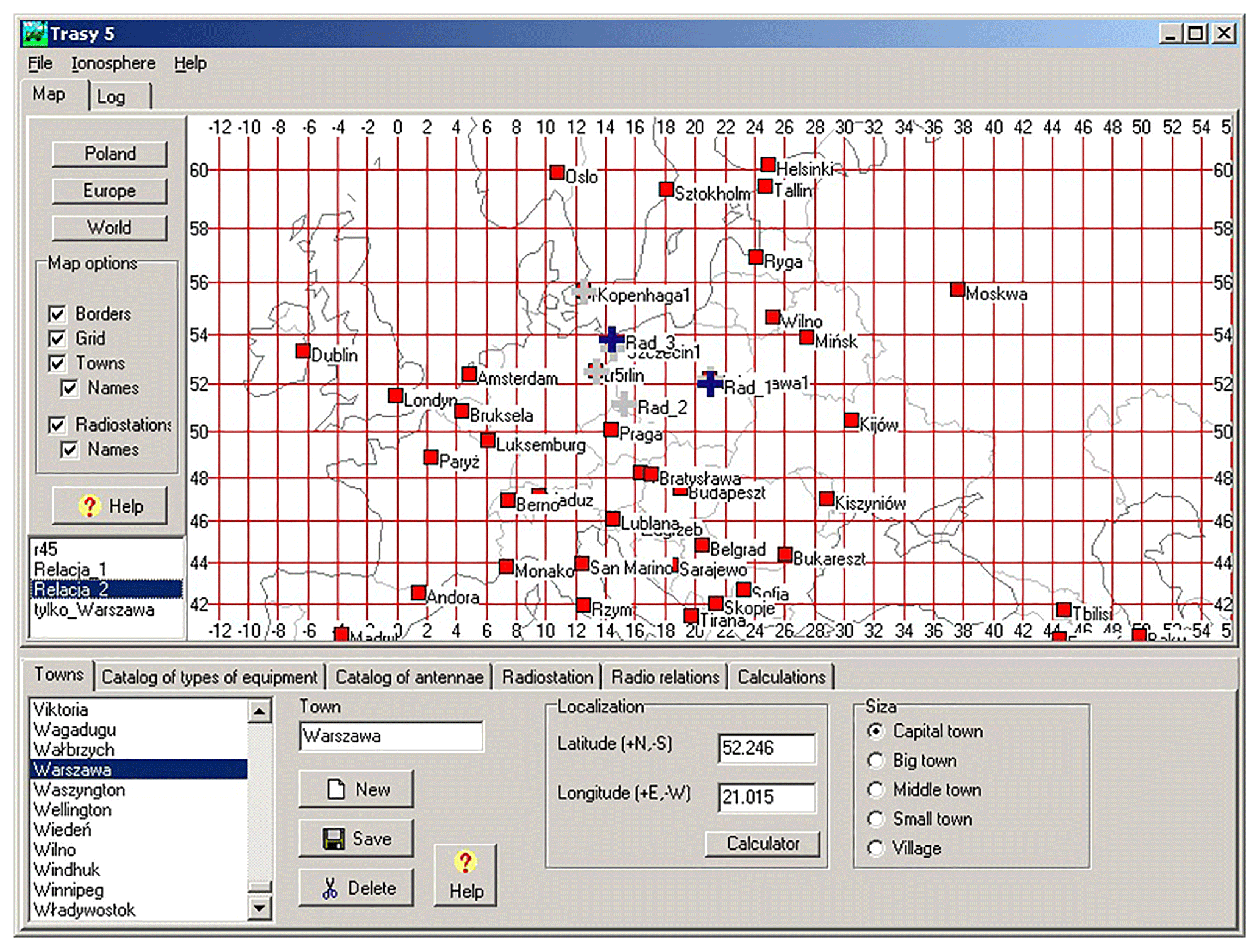
Figure 6One of the first of ray-route programs for online HF propagation condition forecast (every version updated according to the user's request).
It can be illustrated by conveniently accessing the web page http://www.cbk.waw.pl/sweurope/ (last access: 31 December 2008) for recent ionospheric data and ionospheric forecasts for some days in advance for the Ionospheric Despatch Centre in Europe (IDCE) initiated in the frame of COST in 1997, one of the main domains of the RWC Warsaw at that time (Stanislawska et al., 1999). All maps were constructed by means of the system PLES – an instantaneous mapping model (Stanislawska et al., 2000, 2001; Stanislawska and Zbyszynski, 2001). During the mapping procedure the specific algorithm was used which introduces the anisotropy of the region to the mapping procedure by means of the scaling factor (longitude–latitude). The convolution interpolation procedure was used as well as new algorithm of mapping.
3.2 Polish-operated geophysical stations
Monitoring at Svalbard and Antarctica. The Polish-operated Arctic Hornsund station is situated at Svalbard. Its position varies depending on geomagnetic conditions (KP) in relation to the projection of magnetosphere magnetic field lines; the station may be situated under the auroral oval or under open magnetic field lines in the polar cap region. Permanent recordings at Hornsund now consist of the ground-level electric field measured by both a radioactive collector and field mill, vertical air–Earth current density measured by a long wire antenna, and meteorological parameters, consisting of, since 1998, the automatic Vaisala station, three components of geomagnetic field, aurora observations, ionosphere absorption by a riometer, GPS scintillations, spaced receivers, drift measurements, the ionosonde, ionospheric characteristics, and slant and vertical total electron content (TEC). In 1985, the station started to be used gradually, with its monitoring equipment as a data provider for RWC Warsaw services and for applied science development related to space weather data assessment, modelling and prediction. The station operates in current collection of a large portion of the data supply directly to the Space Research Centre (SRC), where it is stored, and/or to international scientific nets like the International Real-time Magnetic Observatory Network (INTERMAGNET; magnetic data). It is continuously monitoring the ionosphere, but the system of online data availability is under development.
Monitoring of the ionosphere with the ionosonde and GPS station at SRC Warsaw. The ionosonde and GPS receiver co-located at the Warsaw station monitor the ionosphere and plasmasphere. Observed disturbances provide a wealth of data not only for instantaneous maps of ionospheric characteristics but also for developing statistics and models. Enriched regional data by solar radio registrations from the Torun station and geomagnetic field real-time data from the Belsk observatory have provided a unique space weather data set. Unfortunately, due to local problems Torun ceased to be a real-time data supplier, but Belsk and Warsaw are still operating. Additionally, in recent years (months), this data set has been enlarged by radio observations from the international low-frequency array (LOFAR) interferometer infrastructure in the Borowiec observatory.
3.3 Service provider
Services included, among others, the following:
-
On the basis of continuous flow of data daily, expected influence of heliogeophysical activity on monthly forecasts of radio-communication conditions throughout the world was prepared for governmental and commercial customers by means of the special developed software package for data processing and the system of prediction of HF communication. The emphasis was placed on the ionosphere disturbances on short-wave radio propagation, satellite-to-ground and ground-to-satellite communications, signal fade and phase change on satellite up and down links, location errors and reception problems when using the GPS navigation system, and location errors in remote sensing of HF radio signals.
-
The SRC-developed software package for data processing and system of prediction of HF communication was continuously modified, and new versions have been provided to users. The system communicates with the mother database in RWC Warsaw in near-real time.
-
Permanent users, like governmental and military telecommunication services, host the SRC software on their own computers and link to the SRC data system to refresh the data set according to their needs.
-
There are five permanent users of our activity and many individual questions from the public (by phone and e-mail).
-
Data collected by the SRC are also useful in ionospheric correction of space radar, and the SRC cooperate with the national centre involved in the European SST programme.
-
At present we are getting to support the International Civil Aviation Organization (ICAO; UN specialized agency) by HF communication forecasts for aviation, and this activity and modification is concentrated on (1) instantaneous use by means of a 3-D mapping profile model; (2) a ray-tracing algorithm application on this type of model that supports the operational phase of selected needs related to applications of the Global Navigation Satellite System (GNSS) signal in space by the space weather ionospheric corrections, taking into account the arctic data; and (3) the attenuation and scintillation effects of atmospheric ingredients on satcom conventional (C band to Ka band) and higher-frequency bands on the base of Météo data (bridge to meteorology).
This part of work is quite a new area for RWC and directly links the improvement and further development of the automated forecast and prediction of space weather effects in the important polar area.
3.4 Applied science
Apart from the day-to-day nowcasting and forecasting, the RWC team has been conducting research on refinement of the prediction technology, developing advanced computer forecasting systems and solving scientific problems concerning the development of various phenomena in the terrestrial environment. Also, theoretical studies on modelling of the space weather phenomena, ionosphere and terrestrial magnetism, and the links between them as well as on the mathematical description of related processes were carried out. This part of work is directly linked to the improvement and further development of the automated forecast and prediction of space weather effects. Thus, GPS-signal ionospheric and tropospheric corrections were evaluated by the effective dielectric permittivity concept. The method gives an assessment of the value of refractive delays of the GPS signal caused by different environments (ionospheric irregularities and the troposphere with its constituents, namely air, water vapour, hydrocondensates, sand and dust).
Use over very short baseline single frequency (L1) differential GPS data to obtain ionospheric correction and avoid the need for a dual-frequency receiver giving correction in an unsmoothed way was made possible (no low-pass filtering is applied before). The practical models are continuously updated.
The RWC's Warsaw team was involved in common European space weather programmes and programmes like COST (related to framework programmes of EU). Our focus was on space weather as “a space weather service” with well-defined service products that are oriented to demand and recognized as a space weather service provider for communication, navigation and aviation to support the operational phase of selected national needs. The associated disturbances in the Earth's magnetic field produced large gradients in the TEC in the mid-latitudes crucial for the GNSS signal in space application for different fields of science and technology. Disturbances are mostly related to space weather hazards. Large and small space and timescales of them required near-real-time monitoring and modelling for technological management applications. So, more ionosondes and GPS–Galileo–GLONASS receivers, including permanent scintillation observations, are needed. For this purpose, new assets appeared in Poland and at the Hornsund station at Svalbard. These give an excellent source of reliable and accurate information. It yields implementation of the new products, such as S4 and sigma phi, as well as ionospheric irregularity drift measurement supplemented with absorption registration with a riometer.
The dependence of modern technology on space weather in society is growing drastically. Thus, for the future our focus is on space weather as “a space weather service” with well-defined services recognized as joint space effect products that are oriented to demand. Expanding tight close cooperation with the users based on permanent feedback ensures that the space system performance meets governmental and commercial customer needs.
Our necessities are defined as the following:
-
integrated application linked to the European programme COPERNICUS, including meteorological effects and supported satcom activity (Stanislawska et al., 2009a),
-
activity in a space weather module of the ESA programme as well as EU-granted Space Situational Awareness actions,
-
a focus on activity related to space safety, including the protection of humanity and assets in space and on Earth from dangers originating in space,
-
a continuously increase in space weather expertise for a wide range of applications in science and technology.
Progress in development of these services will be achieved by the following:
-
continuous high efforts in development of more accurate modelling of description and forecasts of space weather (SW) parameters based on growing physical understanding and advanced data analysis techniques,
-
achieving new knowledge which is published in literature and discussing the progress in the ionosphere research at the national and international forums (Belehaki et al., 2009),
-
applicability of available models recommended by international bodies (Stanislawska et al., 2009b) and, thus, more close cooperation with the respective community,
-
strategically using more of their own ground-based facilities and satellite observations, including new tools such as LOFAR.
Services for governmental and commercial customers in Poland and in the world are our strategic concern.
Historical data are stored at an internal database. All data used for daily reports preparation are available on request.
ZK initiated the project of the Heliogeophysical Forecasting Centre at the Institute of Geophysics and then transferred it to the Space Research Centre of the Polish Academy of Sciences, supervising this activity. IS implemented and further developed all forecasting codes and procedures in everyday practice, finally becoming the head of this centre in 1992. BD-J has been the successor to IS since 2012. IS prepared the paper with contributions from all co-authors.
The authors declare that they have no conflict of interest.
This article is part of the special issue “History of regional warning centers”. It is not associated with a conference.
The authors thank the authority of the Institute of Geophysics at the Polish Academy of Sciences for permission to start this work, paving the way for space weather services, as well as our long-standing co-workers: Maria Milodrowska, Zenia Sawicka, Grzegorz Juchnikowski and Zbigniew Zbyszynski.
This paper was edited by Philip Wilkinson and reviewed by Vyacheslav Burov and three anonymous referees.
Belehaki, A., Stanislawska, A. I., and Lilensten, J.: An Overview of Ionosphere–Thermosphere Models Available for Space Weather Purposes, Space Sci. Rev., 147, 271–313, https://doi.org/10.1007/s11214-009-9510-0, 2009.
Jakimiec, M. and Wasiucionek, J.: Short-term flare predictions and their stationarity during the 11-years cycle, edited by: Donnelly, R., Solar-Terrestrial Predictions Proceedings, III, 54–63, 1979.
Klos, Z. and Stanisławska, I.: Informing-predicting system IPS/HELGEO, Solar-Terrestrial Predictions: Solar-Terrestrial Predictions Proceedings of Workshop at Meudon, France, 18–22 June 1984, NOAA, Boulder, CO, USA, 1986.
Stanisławska, I. and Zbyszynski, Z.: Forecasting of the ionospheric quiet and disturbed foF2 values at single location, Radio Sci., 36, 1065–1071, https://doi.org/10.1029/1999RS002242, 2001.
Stanisławska, I., Gulyaeva, T. L., and Hanbaba, R.: Ionospheric Despatch Centre in Europe, Phys. Chem. Earth Pt. C, 24, 355–357, https://doi.org/10.1016/S1464-1917(99)00011-2, 1999.
Stanisławska, I., Juchnikowski, G., Hanbaba, R., Rothkaehl, H., Sole, G., and Zbyszyński, Z.: COST 251 Recommended Instantaneous Mapping Model of Ionospheric Characteristics – PLES, Phys. Chem. Earth Pt. C, 25, 291–294, https://doi.org/10.1016/S1464-1917(99)00011-2, 2000.
Stanisławska, I., Juchnikowski, G., and Zbyszyński, Z.: Generation of instantaneous maps of ionospheric characteristics, Radio Sci., 36, 1073–1081, https://doi.org/10.1029/1999RS002289, 2001.
Stanislawska, I., Lopatka, J., Rabiej, B., Struzik, P., and Suchanski, M.: The operational meteorology and ionosphere aid of mitigation of SATCOM power margin, XII Krajowe Sympozium Nauk Radiowych URSI, Wyd. Elektroniki PW, publikacje naukowe, ISBN 83-920120-6-2, 2009a.
Stanislawska, I., Belehaki, A., Jakowski, N., Zolesi, B., Gulyaeva, T. L., Cander, Lj., R., Reinisch, B., Pezzopane, M., Tsagouri, I., Tomasik, L., and Galkin, I.: COST 296 scientific results designed for operational use, Ann. Geophys., 52, 423–435, https://doi.org/10.4401/ag-4560, 2009b.
Stasiewicz, K., Maksymienko, M., and Jakimiec, M.: KAZIA – A computer system for solar-terrestrial data processing and objective prediction, Solar-Terrestrial Predictions Proceedings, edited by: Donnelly, R., Washington, D. C., USA, I, 61–66, 1979.